Canmore, Alberta  ·  File: PL20250514

Protect the
Staircase Lands

A proposed 74-unit commercial campground immediately adjacent to an important wildlife corridor and habitat patch, in a wildfire interface and historically undermined area, raises serious concerns for our community, our wildlife, and our water. We believe the Staircase Lands deserve better — as natural park, merged with Quarry Lake, and protected for generations to come.

2,500+ Petition signatures
74 Proposed glamping units
14 Documented concerns

What is being proposed?

74-Unit Commercial glamping campground ("The Trailhaus")
~300/day Estimated peak daily users (74 sites × up to 4 people/site + staff)
Staircase Lands Between Peaks of Grassi & Homesteads neighbourhoods
PL20250514 Development Permit Application, Town of Canmore

The developer, operating as The Trailhaus, proposes a seasonal "luxury glamping" operation on the Staircase Lands — private land embedded within a quiet residential area of Canmore, between the Peaks of Grassi and Homesteads neighbourhoods, adjacent to Quarry Lake, and immediately adjacent to an important wildlife corridor and habitat patch connecting Banff National Park to Kananaskis Country. The site is far from commercial amenities and appears to sit only partially within the Town's 10-minute emergency response zone, while nearby Peaks of Grassi is outside that zone. Proposed access arrangements raise serious unresolved questions about emergency response, traffic, and evacuation capacity.

⚠ Critical Gap

Despite formal requests submitted to the Town on March 4, 2026, no technical studies have been made publicly available — including environmental impact assessments, traffic studies, wildlife conflict assessments, or wildfire hazard reports.

Site location & context — Canmore, AB Open in Google Maps ↗
⚠️
Staircase Lands (Proposed Site)
~10 ha between Peaks of Grassi & Homesteads. Above historic Mine No. 1. File PL20250514.
💧
Quarry Lake Heritage Park
Former open-pit coal mine, reclaimed 1970–82. Located within the same drainage/watershed system as the site. Already experiences significant summer recreational pressure.
🏡
Peaks of Grassi
High-density residential neighbourhood immediately adjacent. Although an alternate campground exit is proposed onto Highway 742 / Three Sisters Parkway, evacuation traffic would still converge at the same constrained four-way intersection serving Peaks of Grassi and the campground entrance.
🏡
Homesteads
Established residential neighbourhood bordering the site to the east. Noise, light, and traffic impacts would be directly felt here.
🐻
Wildlife Corridor
An important wildlife corridor and habitat patch system links Banff National Park to Kananaskis Country through the Quarry Lake & Grassi Lakes area.

From coal seam to Quarry Lake —
and why it all connects

The Staircase Lands and Quarry Lake share the same geology, the same mining history, and the same community struggle. Understanding that history makes the current proposal impossible to view in isolation.

1883 – 1916

Canmore is built on coal — and the Staircase Lands are its foundation

Canmore was established in 1883 as a Canadian Pacific Railway depot, but it was coal that turned the whistle stop into a town. The Canadian Anthracite Coal Company (CACC) opened Mine No. 1 in 1886–1887 along what was then called Whiteman's Creek (now Canmore Creek) — directly below what is today the Staircase Lands. The semi-anthracite coal found in the Cascade Coal Basin was exceptionally rare in North America at the time, burning hot and clean, making it ideal fuel for CPR steam locomotives.

The No. 1 Mine transformed Canmore. By the time it closed in 1916, the mine had established the town's infrastructure, economy, and identity. The hillside above it — the Staircase Lands — was left shaped by that extraction: terraced, disturbed, and laced with the beginnings of what would become a complex network of underground workings reaching deep under the valley.

⛏️

The developer himself acknowledged this heritage — the Trailhaus was originally named "Miners Camp" to "play on the historic nature of the property." The irony is that the very mining history being invoked for branding is the same history that raises legitimate geotechnical and undermining concerns.

1938 – 1979

90 years of mining ends on Black Friday — and leaves a scarred landscape

In 1938, Canmore's two rival coal companies merged into Canmore Mines Ltd., which operated eight underground mines and eventually opened a series of surface (open-pit) operations along the south side of the Bow River. In 1968 alone, Canmore Mines stripped 63,000 tons of coal from five surface pits, including Canmore Creek Mine No. 3 — a 120-foot-deep, 365-metre-long pit that would later become Quarry Lake. The underground workings beneath the Staircase Lands multiplied across multiple seams: some steeply dipping, some faulted, all of them leaving behind voids, pillar remnants, and subsurface instability that persists today.

On July 13, 1979 — known locally as "Black Friday" — the Canmore mines closed after 90 years of operations. The town's economic future looked bleak. The hillsides were scarred. The creek beds were disturbed. And beneath the ground, more than 3,000 kilometres of underground roadways and tunnels lay abandoned under the western slopes.

🗓️

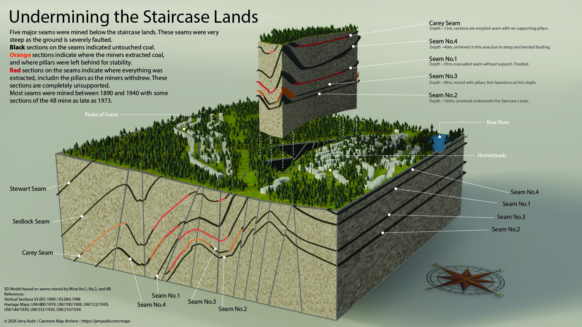
The mine seams beneath the Staircase Lands include the Stewart, Sedlock, and Carey seams — some of the steepest and most faulted in the entire operation. A 3-D analysis by Canmore filmmaker Jerry Auld shows sinkholes from these seams can propagate well beyond their original footprint.

3-D illustration of the historic coal mine seams undermining the Staircase Lands, by Jerry Auld
Undermining the Staircase Lands — 3-D model by Jerry Auld showing five major coal seams mined beneath the site between 1890 and 1973. Steep, faulted seams on the left (Stewart, Sedlock, Carey) are particularly prone to sinkholes that can spread beyond the initial seam boundary. The Peaks of Grassi neighbourhood is visible upper-left; the Homesteads and Bow River at right.
1970s – 1988

A community reclaims a mine pit — and Quarry Lake is born

As the mines wound down in the early 1970s, Canmore Mines Ltd. chief engineer Gerry Stephenson — an avid fly fisherman — was given the task of reclaiming Canmore Creek Mine No. 3. Rather than simply backfilling the pit, Stephenson and his crew partially backfilled the 120-foot-deep pit, sealed the outlet with a clay plug, and allowed the water level to rise to create a fishing hole. The design included both deep and shallow areas for fish, insects, and plants.

Reclamation concluded in 1980 when the Town of Canmore took ownership. The site was officially named Quarry Lake in 1982. Alberta's Environment Conservation Authority called it the best mine reclamation in Western Canada. When the 1988 Calgary Winter Olympics arrived — with Nordic events held at the Canmore Nordic Centre, itself built on reclaimed mine land — the Town invested further in trails, picnic areas, and beach facilities at Quarry Lake.

The transformation of an industrial eyesore into a beloved community park was a landmark achievement, the result of the vision of a few engineers and the sustained commitment of an entire community. Philanthropist Stan Milner and the Rocky Mountain Heritage Foundation later helped the Town purchase the land from the province outright, permanently protecting it as the centrepiece of the 293-acre Quarry Lake Heritage Park.

💧

Quarry Lake and the Staircase Lands share the same watershed. The creek that fed Mine No. 3 still flows through the Staircase Lands. What drains from the Staircase Lands flows, eventually, into the lake that took a generation to restore.

1992 – 1999

The Bow Valley becomes the first place in North America to legally protect wildlife corridors

The 1988 Olympics put Canmore on the map as a destination — and triggered a wave of development pressure that forced the community to ask hard questions about what it wanted to protect. In 1992, the Natural Resources Conservation Board (NRCB) ruled that any development on the Three Sisters lands must integrate designated wildlife corridors. It was a landmark decision that acknowledged the Bow Valley's unique role as the critical link in a wildlife network stretching from Yellowstone to Yukon.

In 1998, the Bow Corridor Ecosystem Advisory Group (BCEAG) — a partnership of the Government of Alberta, the Town of Canmore, Banff National Park, and the Municipal District of Bighorn — published the Wildlife Corridor and Habitat Patch Guidelines for the Bow Valley, the first formal wildlife corridor guidelines in North America. These guidelines became a legal requirement in Canmore's development approval process and established science-based standards for corridor width, design, and management. In 1999 they received a Premier's Award of Excellence.

The Staircase Lands sit squarely within the corridor these guidelines were designed to protect — the movement route linking Banff National Park to Kananaskis Country via the Quarry Lake and Grassi Lakes habitat patches.

🐻

Research by wildlife ecologist Dr. Adam Ford shows most large wildlife in this area spend 95% of their time on slopes under 20 degrees — precisely the valley-bottom terrain the Staircase Lands occupy. This is not marginal habitat. It is the functional heart of the corridor.

2010 – 2022

The land changes hands — and the courts weigh in

The geotechnical risks of developing on undermined land in Canmore are not theoretical. In 2010, an old mine shaft collapsed on the Dyrgas Gate public trail on Three Sisters lands, at significant cost to Alberta taxpayers. The Canmore Commons notes that when developers have previously declared bankruptcy on these lands — which has happened three times, most recently in 2008 — local and provincial taxpayers are left financially exposed by any accidents on the property.

Three Sisters Mountain Village Properties Limited (TSMVPL) purchased the Staircase Lands in 2013. The Town's 1999 and subsequent land use bylaws had designated portions of the lands as Natural Park District, with permitted uses limited to open space, trail, wildlife habitat patch, and wildlife corridor.

In July 2022, the Court of Queen's Bench ordered the Town to either purchase the upper triangular portion of the Staircase Lands or redesignate its use — finding that successive changes to the land use bylaw had effectively restricted the private landowner's development rights. The Town made an offer to purchase the land, but TSMVPL declined. The Staircase Lands were subsequently sold to Prospector Canada LLC, a group of developers and investors based in Colorado. Zachary Richardson — son of TSMVPL owner Blair Richardson — is listed as a managing partner and project developer with Prospector on LinkedIn, and is the landowner behind The Trailhaus proposal.

⚠️

Gerry Stephenson — the engineer who created Quarry Lake and who spent decades studying the Canmore mine workings — was consistently and explicitly opposed to permanent structures on undermined Staircase Lands until his death in 2019. His professional opinion was cited dozens of times in public hearings. It has not been superseded.

2026 – Present

The same battle, the same land, a new proposal

Development Permit Application PL20250514 proposes a 74-unit commercial glamping campground on almost 10 hectares of the Staircase Lands — the same parcel above Mine No. 1, immediately adjacent to an important wildlife corridor and habitat patch, and located within the same drainage/watershed system as the Quarry Lake area that a generation of engineers and community advocates spent decades restoring.

The developer notes the land has "sat idle for 60 years" — but that is not inertia. It reflects a long community consensus that this land is not suitable for high-intensity development: not because of sentiment, but because of geology, ecology, hydrology, and fire risk that are documented, contested, and unresolved.

Quarry Lake was not inevitable. It took a visionary engineer, a committed community, a philanthropist, and decades of sustained effort to transform an open-pit mine into one of the most loved places in Canmore. That legacy deserves better than to have its watershed placed under additional seasonal visitor pressure and its nearby wildlife corridor further stressed by a commercial campground.

🏔️

The Staircase Lands should complete the story that Quarry Lake started — not undo it. The community vision of open space, trail connectivity, and wildlife habitat on these lands is consistent with the Municipal Development Plan, the wildlife corridor guidelines, and the legacy of responsible stewardship that defines Canmore at its best.

14 reasons this
proposal must be denied

Our formal submission to the Town's Planning & Development Department covers the following substantive concerns, grounded in established planning principles, technical studies, and applicable legislation.

🌿
01 / Cumulative Effects
Ecological Tipping Point

The Staircase Lands have already been disturbed by historic coal mining, urban expansion, and recreational pressure. No cumulative effects assessment has been made publicly available, leaving unresolved questions about how the proposal would add to existing ecological and recreational pressure.

Planning Gap
🐻
02 / Wildlife Corridor
A Critical Movement Route

The site lies immediately adjacent to an important wildlife corridor and habitat patch linking Banff National Park to Kananaskis via Quarry Lake and Grassi Lakes. High levels of human activity are known to reduce habitat effectiveness and increase wildlife displacement in sensitive corridor areas. Campgrounds can also create food-attractant risks that contribute to habituation and human-wildlife conflict.

Environmental
⚠️
03 / Human Safety
Campers in a Conflict Zone

Overnight camping in a known grizzly, black bear, wolf, and cougar habitat — in soft-sided structures with food present — dramatically raises the risk of dangerous encounters. The site appears to be only partially within the 10-minute emergency response zone, while nearby Peaks of Grassi is outside it. Parks Canada acknowledges campgrounds are the highest-risk interface for human-wildlife conflict.

Safety Risk
🐕
04 / Domestic Dogs
Stress Without a Leash

Peer-reviewed research (Ward et al. 1976; MacArthur et al. 1979) documents elevated stress responses in elk and bighorn sheep even from leashed dogs. Given existing off-leash enforcement challenges in Canmore, a private campground cannot realistically mitigate this impact.

Environmental
🚧
05 / Mitigation Trap
Fencing That Can't Win

Best practice requires wildlife exclusion fencing — but installing it fragments the very corridor the site occupies. Without fencing, wildlife conflict increases. With fencing, corridor function is lost. This is a fundamental, unresolvable conflict: the site is inherently unsuitable for high-density human use.

Environmental
💧
06 / Water Quality
Quarry Lake at Risk

The Staircase Lands drain to Quarry Lake and Canmore Creek. An additional 300 users daily will accelerate bacterial contamination, nutrient loading, and eutrophication. Research confirms that human-derived inputs are the dominant contamination pathway in small enclosed lakes — and these cannot be fully mitigated with infrastructure alone.

Public Health
🏊
07 / Recreational Pressure
Quarry Lake Is Already Under Pressure

Quarry Lake already experiences significant summer recreational pressure, including crowded conditions, parking overflow into residential streets, and increasing enforcement burden during peak periods. A campground with an estimated peak occupancy near 300 people would add further pressure and municipal servicing costs not offset by the developer.

Infrastructure
📋
08 / Land Use Bylaw
Misclassified Use

The proposed "glamping" use may not align with the Land Use Bylaw definition of "campground." Given semi-permanent structures and commercial characteristics, it may constitute tourist accommodation or resort use — requiring different evaluation criteria. The MDP and LUB are misaligned, and discretionary use criteria are absent from Town documents.

Regulatory
🚗
09 / Traffic Safety
A Dangerous Access Point

The proposed access is located adjacent to an existing four-way stop, creating compounding conflict between intersection control decisions, gap acceptance, and campground ingress/egress. Alberta Transportation guidelines and the TAC Geometric Design Guide both flag this configuration as requiring relocation or intersection redesign. No TIA has been made public.

Safety Risk
🔥
10 / Wildfire Risk
Fuelling the Interface

The site is within a designated wildfire interface zone. The campground introduces ignition sources (campfires, propane, vehicles), increased fuel loads, and transient occupants unfamiliar with evacuation routes. Positioned between two residential neighbourhoods, it creates a potential fire spread corridor — directly contradicting FireSmart principles.

Safety Risk
🚨
11 / Evacuation Capacity
Single Exit, 300 Campers

Evacuating campground occupants plus Peaks of Grassi residents through routes that converge at the same constrained four-way intersection raises serious unresolved capacity concerns. Although the applicant proposes an alternate exit onto Highway 742 / Three Sisters Parkway, it does not appear to create an independent evacuation route. The Peaks of Grassi neighbourhood already has above-planned occupancy from secondary suites, adding unaccounted demand, and nearby Peaks of Grassi is outside the 10-minute emergency response zone.

Life Safety
🏘️
12 / Land Compatibility
Wrong Use, Wrong Place

A high-turnover commercial campground between two established residential communities generates noise, light pollution, and enforcement burdens incompatible with neighbourhood character. The Staircase Lands should be addressed through the Public Use District open space system or the Three Sisters Village Area Structure Plan.

Planning
⛏️
13 / Geotechnical Risk
Built on Mine Shafts

The Staircase Lands are underlain by multiple historic coal seams (mined 1890–1973), including steep faulted seams prone to sinkholes. A 3-D analysis by J. Auld confirms five major seams below the site. Existing geotechnical studies are outdated. Provincial regulations limit developer liability to two years — leaving long-term sinkhole risk with Canmore taxpayers.

Liability
📁
14 / Procedural Fairness
No Transparency, No Trust

Formal requests for all supporting technical studies were submitted on March 4, 2026. As of this writing, no materials have been provided. Without access to environmental assessments, traffic studies, wildlife conflict reports, and wildfire hazard analyses, the public cannot provide meaningful input — and the Town cannot make an evidence-based decision.

Procedural

What The Trailhaus says —
and what the evidence shows

The developer's FAQ attempts to address community concerns. We respect the effort — but the responses rely on assurances without supporting evidence, while the specific risks documented in technical literature, provincial guidelines, and our formal submission remain unaddressed.

💬 What they say

"Protecting wildlife is a central consideration. Technical studies have been completed to understand wildlife movement... the project is being designed to minimize disturbance areas and maintain natural corridors where possible."

📋 The reality

No wildlife corridor studies have been shared publicly despite formal requests. The 1999 Bow Valley Wildlife Corridor Guidelines explicitly call for limiting high-density human activity in these zones. "Maintaining corridors where possible" is not a standard — it's a hedge. Large carnivores avoid areas with sustained human presence even without direct conflict; high levels of human activity are known to reduce habitat effectiveness and increase wildlife displacement in sensitive corridor areas. The mitigations described may be difficult to reconcile with corridor function.

💬 What they say

"The intent is to reduce unmanaged interactions by concentrating visitor use in a controlled environment, actively managing behaviour on-site, and educating visitors before and during their stay."

📋 The reality

This is a fundamentally different claim than wildlife protection. Concentrating an estimated peak occupancy near 300 overnight users immediately adjacent to an important wildlife corridor and habitat patch is unlikely to reduce wildlife disturbance — it would add sustained human presence in a sensitive area. The argument that "managed" human presence is safer for wildlife is not supported by the scientific literature. Bears and cougars do not distinguish between managed and unmanaged campers. A 2026 incident in Banff — a wolf accessing garbage at a managed campground — illustrates that management protocols do not eliminate risk.

💬 What they say

"Pressure at Quarry Lake is largely driven by unmanaged, peak-period day use. This project provides a more structured and accountable visitor experience."

📋 The reality

The developer concedes guests will visit Quarry Lake, only promising "guidance on responsible use." An additional 300 people per day adjacent to an already stressed lake will increase bacterial contamination, nutrient loading, and shoreline pressure regardless of how "accountable" their booking process is. Water quality degradation in small enclosed systems is cumulative and cannot be engineered away. Health Canada identifies human presence itself — not just sewage infrastructure — as the key contamination risk in recreational lakes.

💬 What they say

"The project will include FireSmart-aligned site design, strict controls on fires including one centralized communal fire feature, no open wood fires at individual sites, and emergency response planning."

📋 The reality

The site lies within a designated wildfire interface zone. The concern is not just open campfires — it's the introduction of ignition sources (propane, vehicles, cooking equipment), increased fuel loads (structures, tents, stored wood), and transient occupants unfamiliar with evacuation routes. Legacy surface and subsurface conditions, including coal dust and tailings, as well as methane from historic mining, may also amplify fire risk. FireSmart principles are designed to reduce human activity in interface zones — not accommodate 300-person campgrounds in them.

💬 What they say

"Emergency access is a key requirement and will be designed in coordination with municipal and emergency services to ensure safe access for emergency vehicles, appropriate turnaround and access points, and compliance with fire and safety standards."

📋 The reality

The issue is not whether emergency vehicles can reach the site — it's whether campground occupants plus Peaks of Grassi residents can evacuate simultaneously through routes that still converge at the same constrained four-way intersection. Although the applicant proposes an alternate exit onto Highway 742 / Three Sisters Parkway, this does not appear to create an independent evacuation route; it may instead add evacuation demand to an already limited access point. The developer has provided no evacuation modelling. The site appears to be only partially within the 10-minute emergency response zone, while nearby Peaks of Grassi is outside it; added campground traffic could further complicate emergency access and evacuation.

💬 What they say

"The project is designed to operate as a quiet, low-impact use with on-site management, clear behavioural expectations, and limits on noise, lighting, and activity."

📋 The reality

Neighbour compatibility is not merely a matter of intent — it requires assessment against land use policy. A high-turnover commercial campground adjacent to established residential communities conflicts with core planning principles regardless of promised quiet hours. The fundamental land use incompatibility between transient commercial overnight accommodation and stable residential areas cannot be resolved through operational promises alone, and no compatibility assessment has been shared publicly.

What we'd like to see

This is not simply opposition. We have a constructive vision for the Staircase Lands — one that honours the site's ecology, its history, and its relationship to the community that surrounds it.

🏔️
Our objective

Return to Natural Park — merged with Quarry Lake

The Staircase Lands should be redesignated as Natural Park District and formally merged with Quarry Lake Heritage Park — completing the open space system that Gerry Stephenson and a generation of community advocates began building in the 1970s. Managed jointly by the Rocky Mountain Heritage Foundation and the Town of Canmore, the combined park would protect the wildlife corridor, safeguard Quarry Lake's watershed, and give residents and visitors a connected, ecologically intact landscape in the heart of town.

This is the outcome most consistent with the Municipal Development Plan, the Wildlife Corridor Guidelines, and the long-term stewardship legacy the community has built over 50 years.

Planning process & what comes next

Understanding the process helps you act at the right moment. Your input matters most at specific decision points.

Step 01
Application Submitted

Development Permit Application PL20250514 submitted to the Town of Canmore Planning & Development Department.

Complete
Step 02
Community Petition

2,000+ online signatures gathered since March 9, 2026. 500+ wet-ink signatures since March 13, 2026. Opposition brief submitted.

Complete
Step 03
Technical Review

Town planners reviewing the application against the Land Use Bylaw and Municipal Development Plan. Technical studies must be disclosed publicly.

In Progress
Step 04
Planner's Decision

The Development Officer makes a decision on the permit application. The decision rests with Town planning staff, informed by written public submissions.

Upcoming
Step 05
SDAB Appeal — Open to the Public

If the permit is approved, it can be appealed to the Subdivision and Development Appeal Board (SDAB) — a quasi-judicial body that holds public hearings. This is the primary opportunity for residents to speak on the record. Community standing as documented objectors strengthens this pathway.

If Approved

Your voice matters.
Use it now.

01 / Sign

Sign the Petition

Add your name to the growing list of residents and stakeholders who oppose this application. Both online and wet-ink signatures are being collected.

2,500+ Signatures and growing since March 2026
Sign Online ↗
02 / Write

Contact Town Decision-Makers

A brief, personal email to planners and council carries significant weight. Ask for full disclosure of technical studies and denial of the permit in its current form.

03 / Participate

SDAB Appeal

If the application is approved, it can be appealed to the Subdivision and Development Appeal Board (SDAB) — a public, quasi-judicial process where affected residents can participate through written submissions or in person at the hearing.

Further information on how to participate will be communicated as the process develops.

04 / Share

Spread the Word

Share this page with neighbours, community groups, and anyone who cares about Canmore's wildlife, water, and liveability.

Community awareness is what drives planning accountability.

"Planning decisions of this magnitude require full transparency, community participation, and evidence-based evaluation. The public should not be asked to accept assurances in place of technical documentation when the stakes include wildlife corridors, water quality, wildfire evacuation, and geotechnical stability."

— Staircase Lands Campground Opposition Group, Canmore, AB

What's happening

Key developments in the planning process, community action, and media coverage — newest first. Bookmark this page and check back for updates as the application progresses.

Ready-to-send letter templates

A personal email to planning staff and council carries real weight. Choose a template below, personalize it with your name and street, and send. Three minutes of your time creates a permanent record of community opposition.

Our case is grounded
in established record

Every concern in our submission is supported by legislation, peer-reviewed research, provincial guidelines, or technical analysis. These are the primary references.

Municipal Guideline
Guidelines for Human Use Within Wildlife Corridors in the Bow Valley (1999)
Town of Canmore document explicitly calling for limits on high-density human activity within wildlife corridor areas connecting Banff to Kananaskis.
→ canmore.ca
News / Recent Incident
Camper Fined After Wolf Gets Into Garbage at Banff Campground (2026)
Recent enforcement case demonstrating that even managed campgrounds with established protocols experience wildlife attractant incidents. Directly relevant to proposed site.
→ rmotoday.com
Provincial Guideline
Stepping Back from the Water — Alberta Environment
Provincial guidelines identifying risks from development near water bodies, including shallow groundwater contamination, nutrient loading, eutrophication, and septic suitability in mined terrain.
→ open.alberta.ca
Peer-Reviewed Research
Ward et al. (1976) & MacArthur et al. (1979)
Studies documenting elevated heart rates and prolonged avoidance behaviour in elk and bighorn sheep when exposed to domestic dogs — even when leashed.
Available via academic databases.
Geotechnical Analysis
Undermining the Staircase Lands — J. Auld (3-D Mine Seam Model)
3-D mapping of five major historic coal seams beneath the Staircase Lands, including steep faulted seams and areas of complete pillar removal. Demonstrates sinkhole risk extending beyond seam boundaries.
Available on request from the Opposition Group.
Wildfire Framework
FireSmart Alberta / Bow Valley FireSmart Framework
Provincial framework for managing wildland-urban interface risk. The Staircase Lands site is located within a designated interface zone subject to these guidelines.
→ firesmartalberta.ca
Transportation Standard
Geometric Design Guide for Canadian Roads — TAC
Transportation Association of Canada standard establishing minimum access spacing from intersections. The proposed campground access location adjacent to a four-way stop raises serious compliance questions.
Published by the Transportation Association of Canada.
Federal Guidance
Health Canada — Recreational Water Quality Guidelines
Identifies human fecal contamination and elevated E. coli as key risk factors in recreational waters, directly linking increased human use intensity to illness risk — particularly in small, enclosed lakes such as Quarry Lake.
→ canada.ca
Community Submission
Formal Opposition Brief — File PL20250514 (2025)
The full 18-page community opposition submission to the Town of Canmore Planning Department, covering all 14 concerns with citations, legislation, and planning analysis.
Submitted to planning@canmore.ca. Available on request.